

Satellite imagery has long been an invaluable resource for a wide range of industries, from environmental monitoring to urban planning and disaster response. However, the manual interpretation of these images has proven to be a laborious and time-consuming task, often limiting the speed and efficiency of data analysis. The emergence of auto-digitizing technology is reshaping this landscape, offering a revolutionary approach to satellite imagery analysis. In this article, we delve into the transformative impact of auto-digitizing, exploring its benefits, challenges, and potential applications across various sectors.
The Evolution of Satellite Imagery Analysis
Traditionally, analyzing satellite imagery required human experts to painstakingly identify and digitize objects of interest. This process involved manually poring over images, often at pixel-level detail, and carefully marking out various elements. This labor-intensive approach not only consumed significant time and effort but also introduced the potential for human errors. These limitations led to delays in decision-making and resource allocation, hampering the responsiveness needed in fields like disaster management and urban planning.
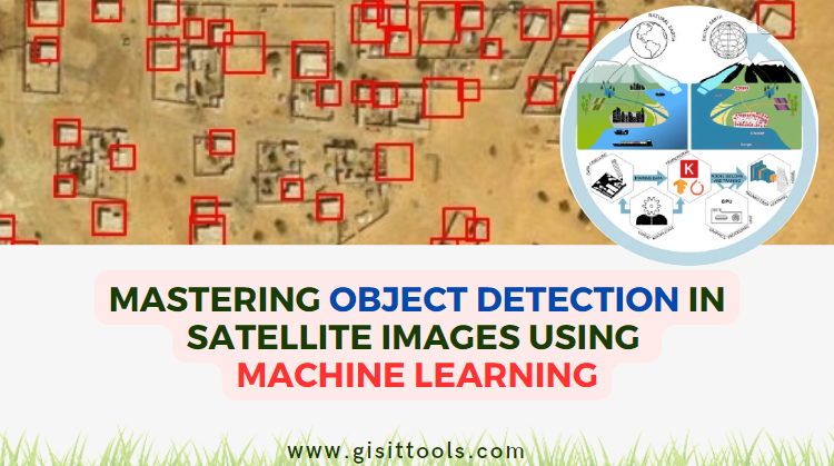
Auto digitizing, powered by cutting-edge artificial intelligence and machine learning algorithms, is changing this dynamic by revolutionizing the way we extract information from satellite images. These advanced algorithms can process vast volumes of data at unprecedented speeds, far surpassing the capacity of human analysis. Leveraging convolutional neural networks (CNNs) and deep learning frameworks, auto-digitizing technology identifies, classifies, and digitizes objects within satellite images with remarkable precision. This includes detecting complex features such as buildings, roads, vegetation types, bodies of water, and even subtle changes over time.
What sets this technology apart is its ability to learn from patterns and features within the data itself. Through extensive training on large datasets of labeled satellite images, these algorithms become increasingly adept at recognizing objects under varying conditions, from different lighting and weather scenarios to different terrains and landscapes. This adaptability makes auto-digitizing a powerful tool in extracting insights from a wide range of satellite images, be it high-resolution images capturing urban sprawl or lower-resolution images used for environmental monitoring.
Furthermore, the integration of auto-digitizing into satellite imagery workflows doesn't replace human expertise; rather, it complements it. Human analysts can focus on higher-level decision-making, validation of results, and refining training datasets for the algorithms. This partnership between human expertise and AI-driven automation ensures that the final insights drawn from satellite images are accurate, reliable, and actionable.
In essence, auto-digitizing technology is not merely automating a manual process; it's fundamentally changing the way we interact with and interpret satellite imagery. By accelerating the identification and classification of objects, auto-digitizing is enabling us to unlock the full potential of satellite data for a myriad of applications, ranging from urban development and environmental conservation to disaster response and agricultural planning. The once time-consuming and resource-intensive practice of satellite imagery analysis is being transformed into an agile, efficient, and precise endeavor that has the power to shape our understanding of the world like never before.
Benefits of Auto Digitizing
1. Speed and Efficiency:
Auto digitizing drastically reduces the time required for image interpretation, ushering in a new era of rapid data processing. What might have taken days or even weeks through manual methods can now be accomplished in a matter of hours or minutes. This heightened efficiency has far-reaching implications, enabling timely decision-making in critical scenarios. For instance, in disaster response, the ability to swiftly identify affected areas and assess damage can mean the difference between effective intervention and prolonged recovery. Similarly, in urban planning projects, the accelerated identification of land use changes allows authorities to adopt policies in real time to support sustainable development. This newfound agility transforms satellite imagery analysis from a time-consuming endeavor into a proactive tool for addressing dynamic challenges on a global scale.
2. Scalability:
In an era of ever-increasing data volume, the scalability of auto-digitizing technology emerges as a game-changing advantage. As the demand for high-resolution satellite imagery continues to surge, the traditional manual analysis approach struggles to keep up. Auto digitizing transcends these limitations by harnessing the power of artificial intelligence and machine learning. Its ability to process vast amounts of data within remarkably short timeframes positions it as the linchpin for large-scale projects that require quick, accurate, and comprehensive insights. Whether it's tracking global environmental changes, monitoring urban expansion, or coordinating disaster response, the scalability of auto-digitizing ensures that decision-makers have access to real-time, data-driven insights on a scope that was previously inconceivable. This capability not only improves the efficiency of analysis but also opens doors to entirely new dimensions of understanding our rapidly evolving world.
3. Consistency:
Human interpretation can vary based on factors like fatigue, subjectivity, and cognitive biases. An individual's mood, experience, or personal perspective can inadvertently influence the interpretation of satellite imagery, leading to inconsistencies and potential inaccuracies. Auto digitizing, on the other hand, operates based on established algorithms and parameters, eliminating the influence of human emotions and cognitive biases. As a result, it provides a standardized and objective approach to image analysis, ensuring a level of consistency that is often challenging to achieve through manual methods. By minimizing the potential for errors introduced by human subjectivity, auto-digitizing significantly enhances the reliability of the generated data, making it a valuable tool for decision-makers across various sectors.
4. Complexity Handling:
Satellite images are complex datasets that capture intricate patterns across vast landscapes. These images might encompass diverse terrains, from densely urbanized areas to sprawling natural landscapes. Auto-digitizing algorithms excel at navigating this complexity, leveraging advanced pattern recognition and deep learning techniques to identify objects and features even in challenging conditions. Whether it's identifying individual rooftops in a crowded urban skyline or tracing the winding paths of rivers through dense forests, these algorithms have demonstrated an impressive ability to decipher and digitize the most intricate details present within satellite images. This capability proves especially valuable in scenarios where manual interpretation might miss subtle yet significant changes, such as detecting illegal land encroachments or subtle shifts in vegetation cover over time.
5. Real-time Insights:
Rapid digitization means that timely decisions can be made based on current conditions, significantly enhancing the effectiveness of critical applications such as disaster response and environmental monitoring. In disaster response scenarios, where every minute counts, auto digitizing enables emergency teams to quickly identify affected areas, damaged infrastructure, and potential hazards. By providing accurate and up-to-date information, decision-makers can allocate resources more efficiently, optimize evacuation routes, and coordinate rescue efforts with precision.
Similarly, in the realm of environmental monitoring, the ability to capture real-time insights through auto-digitizing brings a new level of granularity to tracking changes. For instance, the technology can aid in monitoring rapid shifts in deforestation patterns, enabling authorities to promptly address illegal logging or forest degradation. In coastal regions, where climate change impacts are more pronounced, auto digitizing assists in monitoring shoreline erosion and identifying areas at risk of flooding due to rising sea levels. By generating real-time data on environmental changes, policymakers, scientists, and conservationists can develop more informed strategies for preserving ecosystems and mitigating the effects of climate change.
The fusion of real-time insights and auto-digitizing technology opens doors to proactive decision-making and more effective responses to dynamic situations. As data processing capabilities continue to evolve, the potential for real-time analysis of satellite imagery grows, making auto-digitizing an indispensable tool in shaping our responses to pressing challenges and safeguarding our environment.
Challenges and Considerations
While auto digitizing offers significant advantages, it's not without its challenges:
1. Data Quality:
The accuracy of auto-digitizing relies not only on the quality of the input data but also on the diversity and representativeness of the training dataset. High-resolution images captured under optimal conditions yield the best results, as they provide clear and detailed information for the algorithms to analyze. Images with poor visibility due to factors such as cloud cover, atmospheric interference, or insufficient lighting can lead to inaccurate detections and hinder the algorithm's ability to distinguish objects accurately. Furthermore, variations in image quality across different satellite sensors and platforms can impact the algorithm's generalizability, emphasizing the need for a comprehensive and diverse training dataset to enhance its robustness and reliability.
2. Training Data:
Machine learning algorithms require extensive training on labeled data to perform accurately. Acquiring and labeling such data can be time-consuming and resource-intensive. The process involves manually annotating objects of interest within a vast array of satellite images, a task that demands both domain expertise and meticulous attention to detail. Additionally, the labeling process needs to account for various factors, such as different lighting conditions, angles, and scales, in order to create a robust and adaptable training dataset. Striking a balance between the quality and quantity of training data is crucial, as an insufficient dataset can lead to suboptimal performance, while an overly complex dataset might result in longer training times and increased computational requirements. Despite these challenges, the investment in obtaining accurate and diverse training data lays the foundation for the successful deployment of auto-digitizing algorithms in real-world applications.
3. Complex Terrain:
Auto digitizing faces a unique set of challenges when it comes to identifying objects in rugged or densely vegetated terrain. In such environments, the presence of irregular topography, dense foliage, and occlusions caused by natural elements like trees and rocks can confound algorithms' ability to accurately detect and classify objects. The intricate interplay of light and shadow on steep slopes or beneath a thick canopy of trees can lead to false positives or negatives, compromising the precision of the automated detection process. While modern algorithms have made significant strides in overcoming these difficulties through advanced feature recognition and pattern analysis, it's essential to acknowledge that complex landscapes still pose a testing ground for the adaptability and refinement of auto-digitizing technology. Efforts to improve the handling of these challenges promise to unlock the full potential of auto-digitizing in even the most demanding terrains.
4. False Positives/Negatives:
Algorithms can occasionally produce false positives (detecting objects that aren't present) or false negatives (missing actual objects). These errors can stem from various factors, such as the complexity of the scene, lighting conditions, and the algorithm's threshold settings. False positives can arise when an algorithm misinterprets shadows, patterns, or artifacts as actual objects. For instance, a patch of sunlight on a road might be misconstrued as a vehicle. On the other hand, false negatives can occur when an object's appearance is altered due to factors like weather conditions, occlusion, or scale variations. An instance of a small structure in a densely populated urban area might be overlooked, leading to incomplete data.
Addressing these challenges requires a multi-faceted approach. Fine-tuning algorithm parameters, training models on diverse datasets that encompass a range of scenarios, and integrating contextual information can all help mitigate false positives and negatives. Furthermore, ongoing research and innovation in computer vision and machine learning techniques are continually refining the capabilities of auto-digitizing algorithms, enhancing their ability to discern between actual objects and visual anomalies. As the technology evolves, the balance between reducing errors and maintaining efficiency will be a key focus, ensuring that auto-digitizing continues to drive accurate insights from satellite imagery.
Applications Across Industries
1. Urban Planning:
Auto digitizing aids in urban growth analysis, revolutionizing the way cities plan for the future. By automatically identifying changes in infrastructure, zoning, and land use patterns, urban planners can make informed decisions that shape more efficient and sustainable cities. This technology enables the rapid detection of new construction, expansion of road networks, and shifts in residential, commercial, and industrial areas. As urban areas continue to expand, auto-digitizing provides an invaluable tool for ensuring that growth is strategically managed, optimizing resource allocation, and minimizing environmental impact. Furthermore, it enhances collaboration between city officials, architects, and environmental experts, fostering a data-driven approach to urban development that aligns with the needs of both residents and the environment.
2. Environmental Monitoring:
In the realm of environmental conservation, the role of auto-digitizing technology is especially noteworthy. As our planet faces pressing challenges such as deforestation, water scarcity, and climate change, the ability to monitor and analyze these changes in real time is critical. Auto digitizing provides a dynamic solution for tracking deforestation patterns by swiftly identifying areas where tree cover has been reduced. This capability is invaluable for organizations focused on combating illegal logging and preserving biodiversity. Additionally, the detection of changes in water bodies, such as rivers, lakes, and wetlands, offers insights into shifts in hydrological systems and potential impacts on local ecosystems. Urban sprawl, a growing concern in many regions, can also be effectively monitored through automated analysis, enabling city planners and policymakers to make informed decisions that balance development with environmental preservation. As the global community intensifies its efforts to safeguard the planet, auto-digitizing emerges as a pivotal tool in our arsenal for fostering sustainable practices and informed decision-making in the realm of environmental management.
3. Disaster Response:
In times of crisis, such as natural disasters or humanitarian emergencies, the role of auto-digitizing becomes even more crucial. Swift identification of affected areas, damaged infrastructure, and access routes is vital for efficient and effective disaster response efforts. Auto-digitizing technology allows emergency responders and relief organizations to quickly assess the extent of the disaster's impact, prioritize areas that require immediate attention, and plan evacuation or relief operations accordingly. This real-time analysis can aid in coordinating resources, optimizing rescue missions, and facilitating communication among different response teams. Furthermore, the ability to rapidly digitize the evolving situation on the ground enhances situational awareness, enabling decision-makers to adapt their strategies based on accurate and up-to-date information. Whether it's a hurricane, earthquake, flood, or another calamity, auto digitizing equips responders with the tools they need to save lives, minimize damage, and ensure a more efficient recovery process.
4. Agriculture:
The integration of auto-digitizing technology into agriculture brings about a new era of precision farming. By utilizing satellite imagery and AI-driven auto digitizing, farmers and agronomists can gain critical insights into crop health, growth patterns, and land utilization. This advanced analysis enables early detection of disease outbreaks, nutrient deficiencies, and pest infestations, allowing for targeted interventions and optimized resource allocation. Additionally, auto-digitizing assists in tracking changes in crop boundaries and rotations, facilitating informed decisions about planting and harvesting schedules. With the ability to estimate yields based on comprehensive data, farmers can better plan their operations and contribute to more sustainable and efficient agricultural practices.
5. Infrastructure Development:
Auto digitizing plays a pivotal role in planning and monitoring the construction of critical infrastructure, including roads, buildings, and utilities. By automatically identifying existing structures and features in satellite imagery, this technology assists urban planners, architects, and engineers in making informed decisions. During the planning phase, auto-digitizing helps assess the impact of proposed infrastructure projects on the surrounding environment and existing structures. As construction progresses, real-time monitoring through auto-digitizing ensures that projects stay on track and align with the initial designs. Additionally, the technology aids in identifying potential encroachments, ensuring that construction adheres to zoning regulations and land use plans. The combination of accuracy, efficiency, and real-time insights offered by auto-digitizing is transforming how infrastructure development is approached, leading to more sustainable and well-informed urban growth.
Conclusion
The satellite imagery revolution driven by auto-digitizing technology is reshaping how we interact with and derive insights from the vast amounts of data captured from space. This automated approach not only accelerates the pace of analysis but also enhances the accuracy and consistency of results. While challenges remain, ongoing advancements in machine learning and AI promise to address these limitations, further expanding the applications of auto-digitizing across industries. As we continue to harness the power of artificial intelligence, the future of satellite imagery analysis holds the potential for even more transformative changes on a global scale.
comments
Leave a Reply
Your email address will not be published. Required fields are marked *